
Further information:
Aleksi Räsänen
However, the current maps covering large areas, such as the European Corine Land Cover, do not contain a good understanding of different peatland and wetland types and their management.
To address this gap, in ALFAwetlands work package 1, we developed a machine learning approach to map LULC types and changes in them with satellite imagery, focusing specifically on peatlands and wetlands and their drainage statuses. We used a limited number visually interpreted training points for each LULC type. We applied the approach on seven large, 1–4-million-hectare areas within the European Union, ranging from northern Finland to Pyrenees in Spain and France.
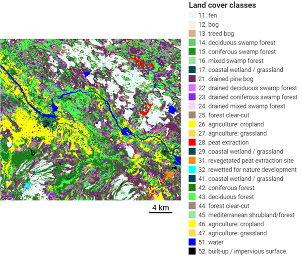
Example of the developed land use land cover map in northern Finland
To construct present-day maps of 27 LULC types, we utilized Sentinel-1 and 2 satellite imagery of the European Copernicus Programme and various additional geographical information databases about soil, topography and LULC. The resulting maps had a moderate to high accuracy, depending on the study area. However, to successfully delineate wetlands, peatlands, and their drainage statuses, additional databases had to be used in addition to satellite imagery.
To detect changes in eight LULC classes between 1985 and 2023, we employed American Landsat satellite imagery. The constructed maps had a high agreement with the historical European Corine Land Cover data. The analysis showed that in each study area, less than 10% of the areal extent has experienced changes.
Overall, the developed approach enables fast and easy implementation of accurate LULC classification and change detection over large areas. The approach can be replicated to other areas and upscaled even to continental scale, such as Europe, but the replication requires training data covering the whole target area.