Monitoring Exports from Forests to Water Courses

The Natural Resources Institute Finland (Luke) monitors the loads from forestry to watercourses through a permanent monitoring network established in 2014. The network includes both forest headwater catchment in natural states and catchments used for forestry. The natural areas serve as a reference point for assessing the impacts of human activity on loadings.
The monitoring provides data on the quantity, quality, and element loads of water discharged from catchment areas. Through this network, forestry operators gain insight into the effects of their activities on water quality, enabling them to use the results for improving water protection and training. Additionally, the long-term impacts of climate change on element loads can be evaluated.
The most significant issue affecting Finnish water bodies is eutrophication and darkening, primarily caused by nitrogen, phosphorus, and suspended solids entering the watercourses. Various sectors, including agriculture, forestry, municipalities, dispersed settlements, and peat production, contribute to this load. The most notable water-related impact from forestry is due to sediment loads caused by ditch network maintenance and the long-term release of nitrogen and phosphorus from old drainage areas.
What is a water export monitoring network of forestry?
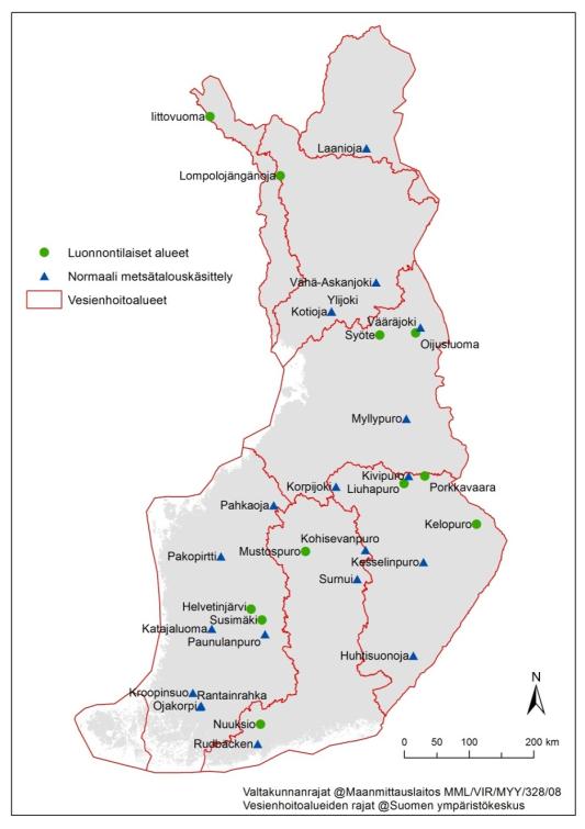
The monitoring network consisting of 31 weir stations is used to monitor changes in water quality and element exports caused by forestry activities in forested headwater catchments throughout Finland. The network was established in 2014 and has significantly enhanced our understanding of the export quantities variations in background leaching, and the underlying factors influencing them. Long-term monitoring stands as the sole method to validate the attainment of emission reductions in forestry practices and assess the impacts of climate change on the loading from the headwater catchments.
The network consists of headwaters established for monitoring the background load of nature and the load caused by normal forestry activities, which include 10 pristine catchment areas and 21 catchment areas used for practical active forestry. Pristine areas provide a reference basis for the exports caused by human activity.
The monitoring network facilitates the generation of national and river basin management area estimates regarding the exports induced by forestry activities. This empowers forestry operators by furnishing insights into the influence of their practices on water quality, thereby facilitating decision-making for water protection initiatives. Furthermore, the network enables the assessment of long-term predictions of climate change on water quality and provides a mechanism for monitoring the impacts of changes in forestry intensity.
The monitoring data can also serve as a basis for evaluating the effectiveness of water protection measures at the national level. This information can be also used for updating the water protection guidelines.
The network represents the whole Finland
The selection of areas included in the monitoring network takes into account the national representativeness, the size of the catchment area and forest management history. Discharge (runoff) from catchment areas is monitored continuously and water quality is monitored regularly by means of water samples.
Water samples are taken manually about 20 times throughout the year, focusing on spring and autumn overflow periods. The temperature of the samples is measured in the terrain and acidity (pH), turbidity (FNU), suspended solids (SS), total phosphorus, phosphate phosphorus (filtered), total nitrogen, nitrate and nitrite nitrogen (NO2+NO3-N), ammonium nitrogen (NH4-N) and total organic carbon (TOC) are determined in the laboratory. Based on the concentration and discharge data, the daily and annual export of each substance from the catchment area is calculated.
Data on the growing stock in the catchment areas are obtained from the Multi-source Inventory of National Forests (MSNFI), and data on fellings, fertilization treatments and drainages are collected annually from the Finnish Forest Centre, Metsähallitus and regional ELY Centres in Finland.
Image
The monitoring network is mainly funded by the Ministry of Agriculture and Forestry and co-financed and coordinated by the Natural Resources Institute Finland (Luke). Monitoring has been carried out in cooperation with the Luke, the Finnish Environment Institute (SYKE), ELY Centres, Metsähallitus, the Finnish Forest Centre and Tapio Oy. Sampling and laboratory analyses are mainly outsourced to private accredited commercial operators.
Updating data
The information will be updated in the service for the year that has ended by the end of May of the following year.
Data and methods
- The data can also be found in the open environmental information management system Hertta on the website of the Finnish Environment Institute.
- The weather data is obtained from Finnish Meteorological Institute